《TAIPEI TIMES》Ocean radar network plans outlined
2026/04/17 03:00
Cabinet officials speak at a news conference in Taipei yesterday. Photo: Chung Li-hua, Taipei Times
MARINE WATCH:Premier Cho Jung-tai said the first task should be to integrate 57 marine radar systems, which use different formats, across government agencies
By Shelley Shan / Staff reporter
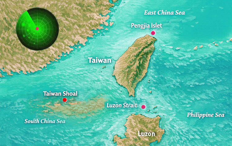
The government is building an ocean radar network to enhance monitoring capabilities in key strategic waters, including the Taiwan Shoal (台灣灘), the Luzon Strait and Pengjia Islet (彭佳嶼), the National Academy of Marine Research said yesterday.
The project was launched last year amid a rise in ocean research activities and marine incidents tied to geopolitical tensions, the academy said.
Academy president Chen Chung-ling (陳璋玲) said the nation’s marine monitoring capacity is insufficient, adding that integrating data collected by radar systems across agencies is a key hurdle, as the systems use incompatible formats.
That might affect navigation safety, and compromise capabilities to monitor marine pollution and prevent natural disasters, Chen said.
Premier Cho Jung-tai (卓榮泰) told a Cabinet meeting that the first and foremost task should be to integrate 57 marine radar systems across agencies, Executive Yuan spokeswoman Michelle Lee (李慧芝) said.
“With its enhanced resilience, the national radar network would cover blind spots in key strategic waters,” Lee quoted Cho as saying. “In addition to covering waters around Taiwan proper, as well as Penghu, Kinmen and Lienchiang (Matsu) counties, the network would also cover Pengjia Islet [50km northeast of Taiwan proper’s northernmost point] and other strategic posts, providing continuous, all-weather updates on marine environmental dynamics.”
The government would also build an offshore oil and gas risk information platform to step up monitoring of environmental conditions in oil and gas hotspots, and provide clear, easy to understand marine safety information to the public, while improving decisionmaking support for disaster prevention and response, Cho said.
The academy said in a statement that the radar network would be collectively constructed by the Ocean Affairs Council, the Ministry of Transportation and Communications, the National Science and Technology Council and the Ministry of National Defense.
With the deployment of ocean remote-sensing radar stations at key points along Taiwan’s coast, the network would enable continuous, all-weather monitoring of sea surface currents, waves and wind conditions, the academy said.
Compared with observations from buoys and ships, remote sensing radar offers a wider coverage areas and continuous marine weather data in high resolution, it said.
The network would expand the observation range to include blind spots in key strategic waters, with those near the Taiwan Shoal southwest of Penghu County, the Luzon Strait between Taiwan and the Philippines and Pengjia Islet being the priority, it said.
It would be used to monitor waters that are recreational hot spots as well, it added.
The goal is to expand the area of surface currents monitored by the radar network to 210,000km2 from 155,000km2 by 2028, enabling all-weather coverage of key waters around Taiwan, Penghu, Kinmen and Lienchiang, the academy said.
Meanwhile, the government would also use artificial intelligence (AI) to expedite the assessment efficiency of incidents in which people fall out of boats and enhance maritime rescue operation precision, it said.
AI would help officials better respond to oil spills, enabling them to instantly estimate the range of affected waters, the academy said.
AI would also help improve rip current detection and public warnings in recreational areas, support small-target detection and enable radar-based tracking of sea surface pollution trends, it said.
新聞來源:TAIPEI TIMES