離開
離開 進入
進入《TAIPEI TIMES》Forecasters watch progress of Pacific storm
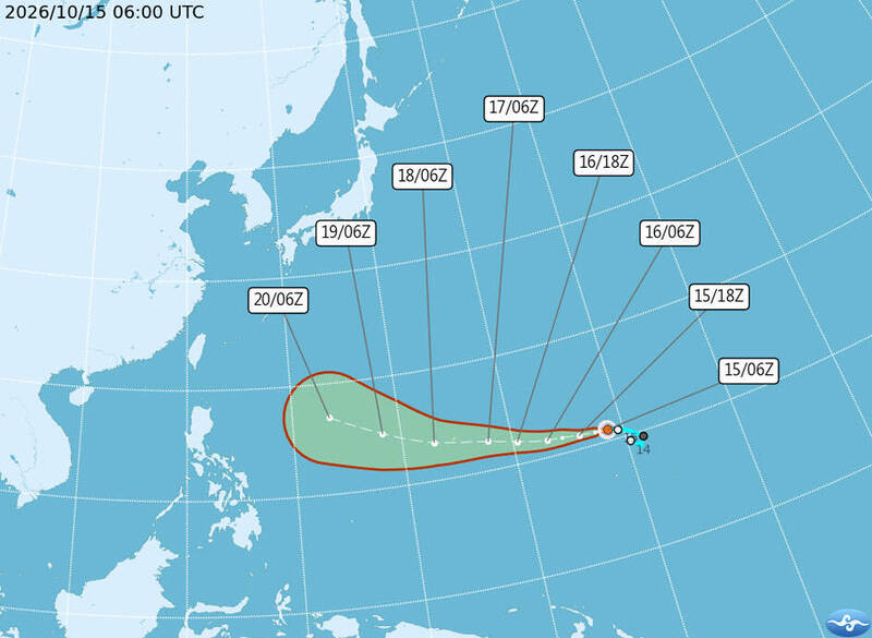
A Central Weather Administration graphic shows the projected path of Tropical Storm Champi as of 8pm yesterday. Photo courtesy of the Central Weather Administration
EAST OF GUAM:Tropical Storm Champi is forecast to strengthen into a typhoon, but its effect on Taiwan is uncertain due to the presence of a high-pressure system
By Huang Yi-ching and Jake Chung / Staff reporter, with staff writer
Tropical Storm Champi formed yesterday and has the potential to increase in strength, the Central Weather Administration (CWA) said yesterday.
Forecasters are closely monitoring a Pacific high-pressure system that would dictate whether the storm turns north or moves toward Taiwan next week, the CWA said.
The most likely scenario is that it turns northward after passing the Ryukyu Islands, CWA forecaster Cheng Chieh-jen (鄭傑仁) said.
As of 8pm yesterday, Champi was east of Guam moving west-northwest at 20kph, CWA data showed.
It had maximum sustained winds near the center of 72kph and gusts of up to 101kph, the data showed.
If the Pacific high-pressure system weakens noticeably, the storm is likely to turn north earlier, but if it strengthens, the typhoon might be closer to Taiwan when it turns, Cheng said.
Champi is forecast to strengthen into a moderate typhoon by tomorrow and an intense typhoon next week, he said.
Rainfall could increase in northern and eastern Taiwan next weekend as the northeast monsoon or the outer circulation of the storm affects the region, Cheng said.
The Taiwan Typhoon Forum’s storm tracker forecasts suggest that Champi could begin turning north after Thursday next week as it approaches waters south of Okinawa, east of Taiwan and northeast of the Philippines.
Meanwhile, rain is expected to increase today, with isolated showers in coastal areas around Keelung, as well as Yilan, Hualien and Taitung counties and the Hengchun Peninsula (恆春半島), Cheng said.
From tomorrow to Tuesday next week, mountainous areas of central and southern Taiwan could have scattered showers in the afternoons, he added.
The next surge of the northeast monsoon is expected to strengthen on Wednesday next week, bringing localized brief showers to the greater Taipei area and Yilan, and isolated brief showers to eastern Taiwan and the Hengchun Peninsula, he said.
Isolated afternoon showers are also possible in mountainous areas of central and southern Taiwan, Cheng said.
The forecast for the latter part of the period would depend on Champi’s track and requires further monitoring, he added.
Until Tuesday next week, daytime highs are expected to be 32°C to 34°C in western Taiwan and 31°C to 33°C in the east, with overnight lows of 22°C to 25°C nationwide, he said.
Although the northeast monsoon is forecast to strengthen, accompanying cold air is expected to be weak, meaning daytime highs of 27°C to 31°C in windward areas, he said.
新聞來源:TAIPEI TIMES