《TAIPEI TIMES》 Formosat-5 images now still better: NSPO official

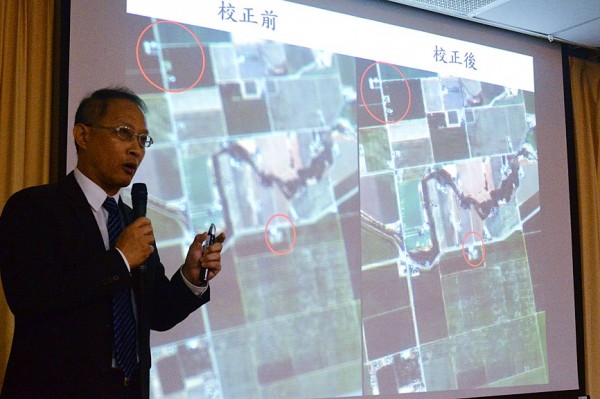
National Space Organization Deputy Director-General Yu Shiann-jen shows blurred and improved images taken by Formosat-5 satellite at a news conference in Taipei yesterday. Photo: CNA
PROGRESS: While images taken by the satellite can now be used for disaster prevention, better resolution is needed for use in urban planning and mapping
By Lin Chia-nan / Staff reporter
Significant progress has been made in improving the imaging capabilities of Formosat-5, a National Space Organization (NSPO) official said yesterday, adding that the imagery can be used for disaster prevention.
Formosat-5, the nation’s first domestically developed satellite, was launched on Aug. 25 from Vandenberg Air Force Base in California. It was designed to deliver black-and-white images with 2m resolution and color images with 4m resolution.
While the images transmitted on Sept. 8 were blurry and tainted with light spots, NSPO officials denied there were any defects in any of the satellite’s components.
Later that month, the agency formed an advisory body of nine experts who offered advice on image adjustment and on identifying the cause of the imaging problem.
Images from Formosat-5 have achieved 5m resolution in color and 3m resolution in black and white when they are properly processed, NSPO Deputy Director-General Yu Shiann-jen (余憲政) told a news conference in Taipei.
While the images are sufficient for disaster prevention, urban planning and mapping would require greater resolution, he said.
Over the past three months, the agency has adopted three improvement measures: adjusting the temperature of the imaging facility, changing the altitude of the satellite and processing images through “deconvolution,” Yu said, adding that only the last measure worked well.
He illustrated the improvement by showing images taken by the satellite of Taipei, Nantou County, San Francisco International Airport and Davis-Monthan Air Force Base in Arizona, which were clearer than their counterparts from September.
The agency has collected more than 1,000 sets of images from the satellite, Yu said.
Davis-Monthan — best known for its so-called “boneyard” for decommissioned US government aircraft — has since the 1970s become the US military’s reference site to test aerial images, said National Chiao Tung University professor Shih Tien-yuan (史天元), a member of the advisory body.
While the root cause of the focus problem has yet to be confirmed, vibration during the satellite’s launch is one possible factor, National Central University professor Liang Chao-wen (梁肇文) said, adding that the design, composition and testing procedures of the satellite would be re-examined.
To make image processing more efficient, the agency plans to purchase new equipment with graphics processing unit systems next year, Yu said.
Asked whether the agency has a timetable for the problem to be completely fixed, Yu said it hopes to make images available to clients in August or September next year, while admitting that the time frame would be a two-month delay.
新聞來源:TAIPEI TIMES


