離開
離開 進入
進入《TAIPEI TIMES》 Manila, Taipei monitor China’s ships
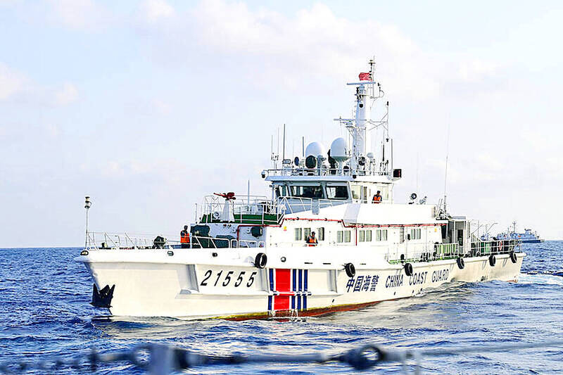
A China Coast Guard vessel is pictured in an undated photograph. Photo: CNA
‘GRAY ZONE’ TACTICS: Beijing sent two China Coast Guard vessels to escort a ‘supposedly private research ship,’ a Philippine Coast Guard spokesman said
By Fion Khan / Staff writer, with CNA
The Coast Guard Administration (CGA) yesterday confirmed that it had recently deployed three patrol vessels to waters in Taiwan’s overlapping exclusive economic zone with the Philippines to monitor three Chinese vessels.
CGA Deputy Director-General Hsieh Ching-chin (謝慶欽) said the agency regularly monitors Chinese vessels around Taiwan, and that the deployment south of Oluanpi (鵝鑾鼻), Taiwan proper’s southernmost point, was carried out in accordance with standard procedures.
He added that the waters fall within the overlapping exclusive economic zones of Taiwan and the Philippines, which extend 200 nautical miles (370km) from their coastlines.
Hsieh made the comments when asked about a statement on Friday by Philippine Coast Guard (PCG) spokesman Jay Tarriela that three Taiwanese vessels were operating near the BRP Teresa Magbanua while it was monitoring three Chinese vessels — a survey ship and two China Coast Guard vessels.
The Chinese research ship, Jia Hai Ke 7 (嘉海科7), has moved north from its loitering position toward the outer limit of the Philippine exclusive economic zone in the Luzon Strait, Tarriela said in a social media post.
The PCG has deployed the BRP Teresa Magbanua to shadow the three Chinese vessels, he said.
The three Taiwanese coast guard vessels were about 0.89, 1.18 and 5.45 nautical miles (1.6km, 2.2km and 10.1km) off the BRP Teresa Magbanua’s port bow respectively, he added.
Beijing sent two China Coast Guard vessels to escort a “supposedly private research ship,” Tarriela said. “This shows again that Jia Hai Ke 7 is not operating on its own.”
“A government law enforcement fleet does not escort a commercial survey ship unless that ship’s mission serves the interests of the state,” he said.
Jia Hai Ke 7, which “spoofed its automatic identification system position to hide its movement,” is a seabed-survey ship that held station for four days in waters crossed by critical submarine cable corridors, he said.
The presence of other maritime law enforcement vessels in the area shows that concerns over this vessel go beyond the Philippines, he said, adding the safety of undersea communications infrastructure in the Luzon Strait matters to the entire region.
The Chinese vessel did not ask for permission to conduct marine scientific research in the Philippine exclusive economic zone, he said.
The BRP Teresa Magbanua would remain in the area and continue to monitor the Chinese vessels, he said.
The PCG would continue to track Jia Hai Ke 7’s movements to “make sure it does not return to Philippine waters to resume unauthorized activities,” he added.
Asked whether the appearance of three Taiwanese coast guard vessels in the Bashi Channel indicated coordinated operations between Taiwanese and Philippine maritime law enforcement agencies, former Philippine Navy vice commander Rommel Jude Ong said the deployments should be seen as separate monitoring missions rather than a joint operation.
Conducting substantive coordination would pose significant logistical challenges for both sides, he added.
Speaking about the strategic importance of the Bashi Channel, he said that in the event of a Chinese attack on Taiwan, the Chinese People’s Liberation Army could seek to seize control of Port of Kaohsiung.
Doing so would require control of the Bashi Channel, while the Batanes Islands could serve as a strategic constraint on such an operation, he said.
That would help explain the Philippines’ increased military presence in the north and its decision to shift some military exercises toward the region, he added.
Tarriela previously said that undersea cables linking the Philippines with northeast Asia and the broader Indo-Pacific region run through waters near the Batanes Islands and the Luzon Strait.
Prolonged loitering by survey vessels in fixed locations could pose a risk to the security of undersea communications infrastructure, while data collected by such vessels could be used for military purposes, Tarriela said.
Military experts have also called the Bashi Channel a key chokepoint connecting the South China Sea and the Pacific Ocean, as well as a vital route to Taiwan’s east coast, with depths exceeding 5,000m that allow submarines to potentially transit undetected.
新聞來源:TAIPEI TIMES